Geography & Climate
The Selati Game Reserve is located in the Lowveld region of the Limpopo province. It sits between longitudes 30° 38’ 42” E and 30° 54’ 26” E and latitudes 23° 54’ 25” S and 24° 05’ 09” S, lying at a mean altitude of around 500m MSL.
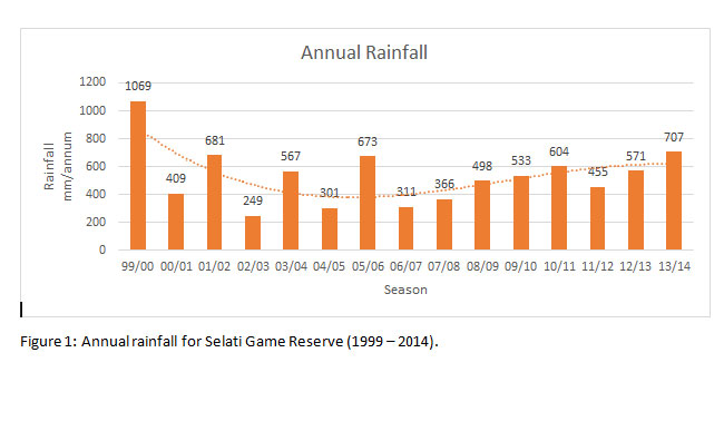
The climate around the reserve is dry with the average annual temperature exceeding 18°C. A mean rainfall of 530 mm nourishes the land on a yearly rate. The area falls within the hot, arid steppe climate zone (BSh) with an evaporation rate that exceeds the precipitation rate.
The reserve has a rich and diverse geological history. The Murchison Greenstone belt, situated in the north-west of the reserve, inhabits the oldest rock formations on earth. The remainder of the reserve is made up of three different granite and pegmatite formations; the Willie, Lekkersmaak, and Mashishimale gneisses. The most spectacular of these is the latter in the south, which protrudes on the Lillie rough-hewn boulders and provides the ideal habitat for Encephalartos dyerianus, the rarest cycad on the planet.


